Home Page
Project Information
Documents
Dam Background and Existing Conditions
The dam in consideration is the Odell dam, located in Munds Park, Arizona. This is roughly 20 miles south of Flagstaff, Arizona.
The exact location of the Odell Dam is latitude N34°56’0.0666” longitude W111°38’0.5562” at center,
From Arizona Dams (1996), the Nation Inventory of Dams ID is AZ00156, and is considered to be of significant hazard. The dam is an earthen dam, gravity fed, and its primary purpose is the storage of water as a recreational lake. The dam’s construction was finished in 1978, and measured to be approximately 20 feet in height and 460 feet across.
The Arizona Department of Water Resources (ADWR) has deemed the status of the dam to be an ‘unsafe dam requiring rehabilitation or removal’, because the dam spillway does not meet the minimum incoming design flood requirement.
Project Hours and Costs


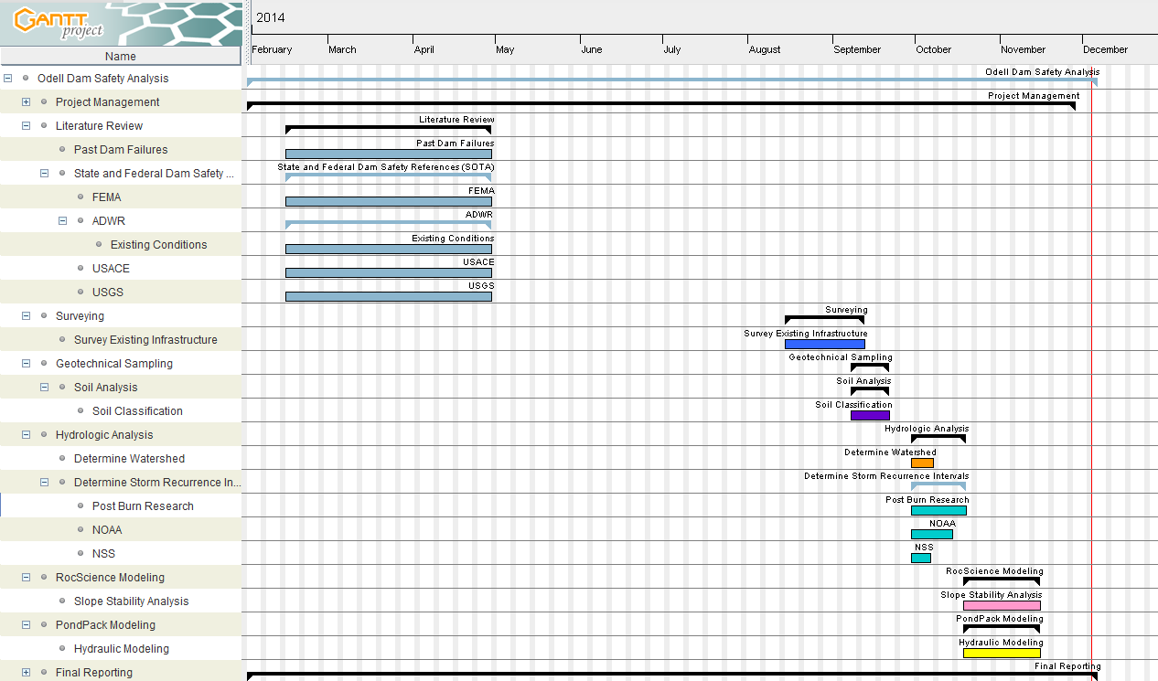
Listed above is an outline of the staffing plan that will be used for the entirety of this project. The project has been broken down into primary tasks which have been broken down into subtasks. Each task and subtask has been assigned a leader who will make sure that their subtask is being completed by the scheduled due date. The subtasks, dates, and time allotted to each task are estimates.
Project Constraints
Some potential challenges the team might experience has been established to be the following:
-
Not all preexisting data could be found, or still exists.
-
Not all data needed is available.
-
Some data may be outdate
-
Scopes of Services
The team will perform the tasks mentioned below for the client in regards to the Odell Dam Safety Analysis (ODSA).
Task 1 – Project Management
Task 2 – SOTA Researching
Task 3 – Site Inventory
Task 4 – Geotechnical Analysis
Task 5 – Watershed Analysis
Task 6 – Dam Failure Analysis
Task 7 – Modeling - Dam Breach Inundation
Task 8 – Final Reporting
For a more details on the Tasks, click here.
Dam Background and Existing Conditions
The dam in consideration is the Odell dam, located in Munds Park, Arizona. This is roughly 20 miles south of Flagstaff, Arizona.
The exact location of the Odell Dam is latitude N34°56’0.0666” longitude W111°38’0.5562” at center.
From Arizona Dams (1996), the Nation Inventory of Dams ID is AZ00156, and is considered to be of significant hazard. The dam is an earthen dam, gravity fed, and its primary purpose is the storage of water as a recreational lake. The dam’s construction was finished in 1978, and measured to be approximately 20 feet in height and 460 feet across. The dam has been deemed High Hazard Class by the 2013 State of Arizona Hazard Mitigation Plan Risk Assessment, and is defined by the “loss of life is probable and one or more is expected”, as well as economic and environmental impacts will occur if the dam fails. Thus the ADWR has determined the dam to be an ‘unsafe dam requiring rehabilitation or removal’.
The dam has a concrete spillway located at the south end. The spillway has rock and concrete debris larger than 1ft in diameter, thus giving a high roughness coefficient to slow down the discharge traveling through the spillway. Currently the volume of water stored within the dam is lower than normal, which is indicated by waterlines at the shore.
Gantt Chart

Final Recommendations
The link below is the final analysis and recommendations created by the Odell Dam Safety Analysis team, using RocScience Slide modelling and Bentley's PondPack modelling.